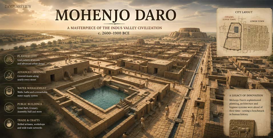
Mohenjo Daro means “Mound of the Dead Men.” This ancient city sits in Sindh, Pakistan, and it once housed thousands of people over 4,000 years ago. The Mohenjo Daro map shows something rare for its time. It shows real planning.
Most old cities grew messily. Homes popped up around temples or palaces with no fixed order. Mohenjo Daro did not grow like that. Builders laid it out on a grid before anyone raised a single wall. Straight streets crossed at right angles. Homes had private wells and bathrooms. Covered drains ran below every street.
This city belonged to the Harappan Civilization, one of the world’s earliest urban societies. Archaeologists found it in 1922. Today, its map helps you see how ancient people managed water, waste, and daily life. Read on to explore the map area by area.
Where Is Mohenjo Daro Located?
Mohenjo Daro sits in the Larkana District of Sindh Province in present-day Pakistan. It lies close to the Indus River, on its western bank. This makes it one of the most studied Sindh archaeological sites today.
| Detail | Information |
| Country | Pakistan |
| Province | Sindh |
| District | Larkana |
| Nearby river | Indus River |
| Coordinates | 27°19′45″N, 68°08′20″E |
| Distance from Larkana city | About 28 km (17 miles) |
| Estimated mapped area | 240 to 300 hectares |
Mohenjo Daro was built on a raised ridge above the Indus River floodplain. Builders picked this spot on purpose. The height gave the city natural safety from floods.
The river gave people fresh water, fertile soil, and a trade route to the Arabian Sea. This choice shows how much thought went into ancient city planning at Mohenjo Daro.
Mohenjo Daro Map
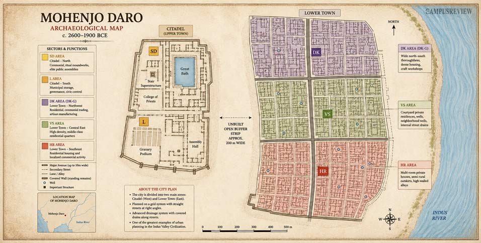
The Mohenjo Daro map below shows the complete layout of the ancient city in present-day Pakistan.
The map of Mohenjo Daro splits the city into two main parts. The west side holds the Citadel, built on a raised platform. The east side holds the Lower Town, where most people lived and worked. An open strip of land, about 200 meters wide, separates these two parts.
Streets run in straight lines. Main roads run north to south. Smaller lanes cross them at right angles. This grid pattern makes Mohenjo Daro one of the clearest examples of planned urban life anywhere in the ancient world.
Key Places on the Mohenjo-Daro Map
Great Bath
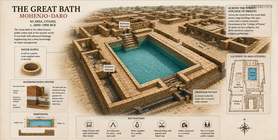
The Great Bath sits inside the Citadel, in a zone called the SD Area. Experts call it the oldest public water tank in the ancient world.
- Size: about 12 meters long, 7 meters wide, and 2.4 meters deep
- Entry: two brick staircases, one from the north and one from the south
- Waterproofing: fine bricks set in gypsum, backed with natural tar
- Water supply: a well in a nearby room
- Drainage: a corner outlet leading into a covered street drain
Across the street from the bath stood a large building with open rooms. Experts call it the “College of Priests.” No one knows its exact use, but it likely held public or religious gatherings.
Citadel
The Citadel rises about 12 meters above the rest of the city. Builders raised it on a huge platform made of mud bricks. This kept it safe during floods.
The Citadel did not hold royal palaces or tombs. Instead, it held public buildings. Thick mud-brick walls, towers, and platforms protected this area from floods and from outside threats. This zone formed the administrative heart of the city.
Lower Town
The Lower Town lies east of the Citadel. Most people in the city lived here. It held homes, workshops, and markets.
Streets divided this area into neat blocks. People lived in baked brick houses with high outer walls and no windows facing the street. Inside, each home had an open courtyard for light and air.
Many houses had private wells, bathrooms, and drains. Some homes even had two floors, with stairs leading up. Workers made beads, pottery, and metal tools in small shops scattered through this zone.
Granary
The Great Granary sits on the west edge of the Citadel. It covers more than 830 square meters. Its base has 27 brick platforms, split by narrow gaps.
Sir Mortimer Wheeler believed these gaps let air flow under wooden grain bins to stop mold. He thought wagons brought grain in through loading bays.
New research questions this idea. Some experts now think the building may have stored more than grain. It might have worked as a treasury or a hall for public business. Either way, the Great Granary shows the city took storage and public resources seriously.
Assembly Hall
The Assembly Hall stands in the southern part of the Citadel. It is a large square building with 20 thick brick pillars, set in four rows of five.
These pillars held up a heavy wooden roof. The hall had no thrones, altars, or statues. This tells experts it likely served a civic use, not religious worship.
Many believe leaders met here to manage trade, taxes, and city rules. This makes the Assembly Hall one of the earliest known examples of an organized civic government space.
Drainage System
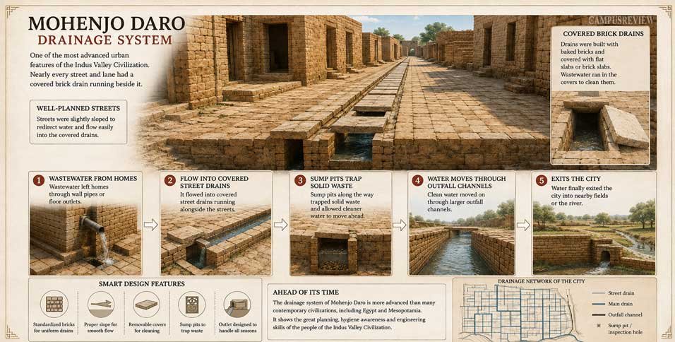
The drainage system at Mohenjo Daro stands out even today. Nearly every street and lane had a covered brick drain running beside it. Here is how it worked, step by step:
1. Wastewater left homes through wall pipes or floor chutes.
2. It flowed into covered street drains.
3. Sump pits along the way trapped solid waste.
4. Clean water moved on through larger outfall channels.
5. It finally exited the city into nearby fields or the river.
Workers could lift the drain covers to clean them. This drainage system beat anything else built at that time, even in Egypt or Mesopotamia.
What Does the Mohenjo Daro Map Tell Us?
The Mohenjo Daro map tells you more than just where buildings stood. It tells you how people lived, worked, and governed themselves.
Grid street layout: Straight streets crossing at right angles show real city planning. Builders laid out roads before homes went up. Even after floods, people rebuilt homes along the same lines. This means strict rules controlled construction.
Advanced drainage: Nearly 700 wells stood across the city. Clean water stayed separate from wastewater. This kept the city healthy and shows a real focus on public hygiene.
Planned neighborhoods: Homes sat in neat blocks. Rich and poor areas sat close together rather than staying fully apart. This points to a fairly balanced society.
Public buildings: The city has no palaces or war monuments. Instead, it has baths, halls, and storage buildings. This tells you power likely sat with groups of leaders, not one king. Trade and public life mattered more than war.
Interesting Facts About the Mohenjo Daro Map
Every baked brick in the city follows one exact ratio: 1:2:4. Each brick measures 7 cm thick, 14 cm wide, and 28 cm long.
- The city held more than 700 wells, one of the highest counts found at any ancient site.
- The Great Bath used natural tar as waterproofing, one of the earliest known uses of this method.
- A 200-meter open buffer strip separated the Citadel from the Lower Town.
- No palace, weapon store, or war monument has ever turned up at the site.
- Mohenjo Daro used underground sewers, while many Mesopotamian cities dumped waste straight into open streets.
Final Thoughts
The Mohenjo Daro map offers a clear picture of one of the world’s earliest planned cities. From its straight streets and advanced drainage system to the Citadel and Great Bath, the map reveals how the people of the Indus Valley built an organized and efficient urban center over 4,000 years ago.
Exploring the Mohenjo Daro map helps you better understand the city’s design, daily life, and lasting importance in human history.
FAQs
1. Which is the most famous landmark of Mohenjo Daro?
The Great Bath is the most famous landmark. It sits inside the Citadel and ranks as the oldest known public water tank in the world.
2. How old is Mohenjo Daro?
Mohenjo Daro grew around 2500 BCE and stayed active until about 1900 BCE. People likely left the site by around 1700 BCE. This makes it over 4,000 years old.
3. Is Mohenjo Daro a UNESCO World Heritage Site?
Yes. UNESCO named Mohenjo Daro a World Heritage Site in 1980. It holds the title of South Asia’s first site on the list.
4. Can you visit Mohenjo Daro today?
Yes. Mohenjo Daro is open to visitors in Sindh, Pakistan. It is a UNESCO World Heritage Site and one of the most important archaeological sites of the Indus Valley Civilization, attracting historians, students, and tourists from around the world.