Ships disappear. Aircraft go missing. For decades, stories of mysterious events have surrounded a stretch of the Pacific Ocean near Japan known as the Devil’s Sea or Dragon’s Triangle.
Located south of Japan, near the Izu and Ogasawara Islands, this region has gained a reputation similar to the Bermuda Triangle. But how much of its mystery is supported by evidence?
From the disappearance of ships to underwater volcanic eruptions, this article explores the Devil’s Sea’s location, famous incidents and scientific explanations behind its mysterious reputation.
Devil’s Sea at a glance
| Question | Quick answer |
| What is it? | An informal name for rough, volcanic waters south of Honshu, Japan. No official map shows it. |
| Other names | Dragon’s Triangle, Ma-no Umi, Pacific Bermuda Triangle |
| Why is it famous? | Several ship and aircraft losses between 1952 and 1975 were later called mysteries. |
| What really happened? | Volcanic eruptions, storms, fuel problems and explosions caused the documented losses. |
| Is it dangerous now? | It stays a busy and sometimes rough sea. Modern ships cross it every day. |
Where Is the Devil’s Sea Located?
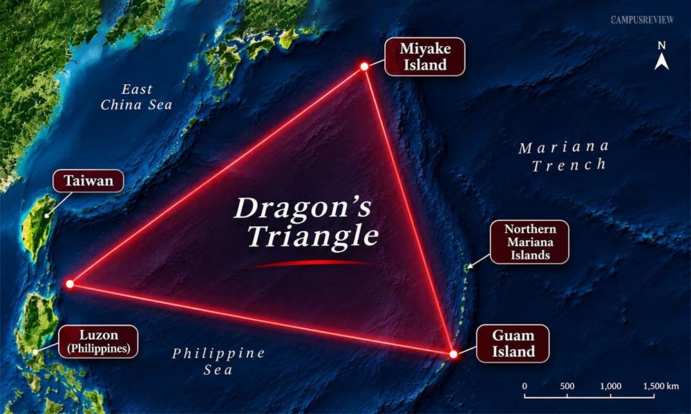
The Devil’s Sea sits in the western Pacific Ocean, south of Honshu, Japan’s main island. It covers waters around the Izu Islands and the Ogasawara Islands, and it reaches toward the Philippine Sea.
Geographical location
The area lies mostly on top of the Philippine Sea Plate. To the east, the Pacific Plate dives beneath it along the Izu-Ogasawara and Mariana trenches. This is part of the Pacific Ring of Fire, so volcanoes and earthquakes are common here.
Most of the famous incidents happened between about 20°N and 35°N latitude and 135°E and 145°E longitude.
Nearby islands
- Izu Islands: A volcanic chain south of Tokyo. Izu Oshima, Miyake-jima, Hachijo-jima and Aogashima belong to it.
- Ogasawara Islands: Also called the Bonin Islands. Chichi-jima and Haha-jima are the main inhabited ones.
- Volcano Islands: Nishinoshima and Iwo Jima sit farther south along the same volcanic line.
- Myojin-sho: A submarine volcano about 450 km south of Tokyo. It plays a big role in this story.
- Mariana Islands: Guam and Saipan mark the southern end of the arc.
Approximate boundaries
No official body draws a line around the Devil’s Sea. The International Hydrographic Organization does not list it as a named sea. So the size depends on who you ask.
| Version | Area covered | Approximate size |
| Japan Coast Guard warning (1952) | Waters around the Myojin-sho volcano | About 10 nautical miles in radius |
| Traditional Japanese usage | Rough waters near Miyake-jima and the Izu Ridge | Regional, a few thousand square kilometres |
| Charles Berlitz’s Dragon’s Triangle | From Cape Nojimazaki, Chiba, south toward Guam, then west toward Taiwan | About 1.5 million square kilometres |
The real danger zone in 1952 was tiny. Later writers stretched it across a huge area. That change made the legend bigger than the facts.
History and Origin of the Dragon’s Triangle
Origin of the name
Ma-no Umi is an old Japanese phrase. It describes any treacherous stretch of water, such as a rough strait or a reef zone. Japanese papers used it for dangerous seas around the world.
The phrase stuck to the waters south of Tokyo in January 1955. A fishing boat went silent, and newspapers linked it to earlier losses. The boat later came home safely, but the name stayed.
American author Charles Berlitz brought the idea to a global audience. He described the area in his 1974 book The Bermuda Triangle. He then wrote The Dragon’s Triangle in 1989.
Japanese legends and folklore
Japanese myths describe dragons as water gods, not fire-breathing monsters. The most famous is Ryujin, the Dragon King of the Sea. He lives in an undersea palace called Ryugu-jo. Stories say he controls the tides with magical jewels. His anger brings storms, whirlpools and tidal waves.
Fishermen near the Izu Islands also saw real wonders. Underwater eruptions turned the water yellow. Steam rose from the waves. Rafts of black pumice floated for miles. New islands rose and then sank within months. Without modern science, people blamed a restless dragon.
Connection with the Bermuda Triangle
American writer Ivan T. Sanderson linked the two places in 1972. He listed twelve “Vile Vortices” around the globe, and he named the Bermuda Triangle and the Devil’s Sea as top examples. Sanderson claimed strange energy rifts caused the losses. Berlitz then promoted the pair as twin mysteries.
Scientists found no proof for these energy claims. The link between the two places came from books, not from measurements.
Famous Ship and Aircraft Disappearances
Six incidents helped build the Devil’s Sea legend. At first, they seem mysterious, but a closer look at the records reveals what may have happened in each case.
Kaiyo Maru No. 5 (1952)
- Date: September 24, 1952.
- Location: Near the Myojin-sho volcano, south of Tokyo.
- Purpose: A Japanese survey ship went to study a new volcanic island. A fishing boat had spotted the island only a week earlier.
- What happened: The ship left Tokyo on September 23. It sent a routine telegram that evening and then went silent. Sound recorders picked up a huge blast around 12:20 pm the next day. Searchers later found wreckage drifting south of the volcano.
- Cause: A Japan Coast Guard inquiry concluded that an underwater eruption destroyed the ship. All 31 people on board died, including nine scientists. The Smithsonian Global Volcanism Program also records the event as a volcanic disaster.
Shinyo Maru No. 10 (1955)
- Date: Radio contact stopped on January 4, 1955.
- Location: Waters off Mikura-jima in the Izu Islands.
- Purpose: A commercial tuna fishing trip.
- What happened: The boat missed its radio calls in harsh winter weather. Newspapers called it another victim of the Devil’s Sea.
- Outcome: The crew was safe. The radio had failed, and strong headwinds slowed the boat. It reached port on January 15 with its catch and all hands. This case gave the legend its Japanese name.
California Maru (1970)
- Date: February 9 to 10, 1970.
- Location: About 250 miles off Cape Nojima, on Japan’s Pacific coast.
- What happened: This 34,000-ton bulk carrier met a fierce winter gale. It radioed that its bow was damaged and leaking. A New Zealand freighter, the Aotearoa, rushed to help and pulled most of the crew to safety. The captain stayed on the sinking ship.
- Cause: Storm waves broke the ship’s structure. Reports differ on exact crew numbers, but all point to a gale, not a vanishing. A similar ore carrier, the Bolivar Maru, broke in two nearby in January 1969.
Fuji Television Aircraft JA3414 (1970)
- Date: February 10, 1970.
- Location: Off the coast of Chiba Prefecture.
- Purpose: A chartered light aircraft flew out to film the California Maru rescue.
- What happened: The pilot struggled in stormy, poor-visibility conditions. Fuel ran low, and the crew radioed a ditching message.
- Outcome: The plane crashed into rough seas. Three people died. Some legend books wrongly call it a “JAL-341” airliner that vanished in calm skies.
Japan Maritime Self-Defense Force P2V Aircraft (1971)
- Date: July 16, 1971. Some legend sources wrongly give April 27.
- Location: Off Cape Choshi, Chiba Prefecture.
- What happened: A patrol aircraft flew a low approach in thick fog. It clipped treetops and damaged a wing. The crew turned out to sea and sent a distress call. Then the plane lost control.
- Outcome: Rescuers found engine parts, wreckage and the remains of all 11 crew members. It did not vanish.
Berge Istra (1975)
- Date: December 30, 1975.
- Location: Philippine Sea, near Mindanao. This is far from the usual Devil’s Sea core.
- Purpose: A huge ore-bulk-oil carrier was hauling iron ore from Brazil to Japan.
- What happened: Radio contact stopped. Officials declared the ship missing on January 7, 1976. The search ended on January 16.
- Survivors and outcome: Two sailors survived 20 days on a raft before rescue. The other 30 crew members died. Survivors reported an explosion, possibly caused by gas vapours from earlier oil cargo. Poor maintenance and crew training were also cited. The sister ship, Berge Vanga, disappeared in 1979.
Natural Phenomena in the Devil’s Sea
The Devil’s Sea mixes several natural hazards in one place. Each one can sink a ship without warning. Together, they explain why this area earned its reputation.
Underwater volcanic eruptions
The Izu-Ogasawara arc holds many underwater volcanoes. When hot magma meets cold seawater, the water flashes into steam. That steam causes violent blasts. Myojin-sho produced one in 1952 and even made a tsunami about 2 metres high, according to the Smithsonian Global Volcanism Program.
Eruptions also release gas. Gas bubbles make seawater lighter, so a ship loses its lift and can sink fast. The Nautical Institute lists the Kaiyo Maru No. 5 as a classic example of volcanic danger to ships.
Earthquakes and tsunamis
The seafloor in this region is constantly shifting as tectonic plates move against each other. Strong earthquakes can disturb the seabed and trigger tsunamis. In deep water, tsunami waves are usually low but travel very fast. As they reach shallow areas, they grow taller and can overwhelm small boats.
Strong ocean currents
The Kuroshio Current, called the “Black Tide,” flows past Japan’s south coast. It is one of the strongest currents in the world. It moves tens of millions of cubic metres of water every second at speeds of 3 to 5 knots.
Old wooden fishing boats had weak engines. The current could push them far off course, toward reefs or storms. That is one reason many boats seemed to “disappear.”
Sudden storms and rogue waves
Two types of storms affect this region. Typhoons are common from June to November. In winter, powerful storms can form when cold air from Asia meets warm air over the Kuroshio Current.
Strong winds can make the waves steeper and more dangerous. Some waves can reach great heights and damage ships. In rough conditions, a vessel can be pushed into a deep wave trough and hit by breaking waves. These conditions can threaten ships such as the California Maru.
| Hazard | What it does | Case example |
| Underwater eruption | Blasts and gas lower water density | Kaiyo Maru No. 5 (1952) |
| Winter storm and rogue waves | Waves crack the hull | California Maru (1970) |
| Strong current | Pushes weak boats off course | Small fishing boats in the 1950s |
| Tsunami | Grows taller over shallow reefs | Possible near volcanic shoals |
Scientific Explanations Behind Devil’s Sea Mysteries
Researchers have studied these cases for decades. Larry Kusche’s 1975 book The Bermuda Triangle Mystery: Solved took a close look at the legend’s weak spots. His method was simple. He checked the original records. Many dramatic claims did not match them.
Volcanic activity
The 1952 case shows how real the hazard is. Japan’s own warning covered only a small zone around the volcano. Writers later inflated that zone into a giant triangle. Eruptions can also explain quick sinkings with little wreckage, because the ship breaks apart in seconds.
Extreme weather conditions
Weather records show that most losses happened in gales, typhoons or heavy fog. Claims of “calm seas and clear skies” do not match the data. Winter storms near Cape Nojima have broken several large cargo ships.
Navigation and mechanical failures
Many post-war Japanese fishing boats were small and made of wood. They had weak radios and no radar. A radio failure could make a healthy boat look lost. The Shinyo Maru No. 10 is the best example. Aircraft losses came from low fuel, fog and pilot error, not from magnetic tricks.
Despite the stories, no official report on these incidents identifies a compass malfunction as the cause. Instead, the records point to more familiar dangers, including severe weather, fuel problems, human error and explosions.
Myths versus documented evidence
| Legend claim | Documented fact | Case |
| Ships vanished in calm weather | Gales, typhoons or fog affected most losses | California Maru, Fuji TV aircraft |
| The crew was never found | The crew was safe, or wreckage was found | Shinyo Maru No. 10, P2V aircraft |
| Japan banned a huge zone | Japan warned about a small area near one volcano | Myojin-sho warning, 1952 |
| The zone is a vast triangle | Some cases happened 1,000 miles away | Berge Istra, 1975 |
| Hundreds of people died in two years | Berlitz gave a figure that has no confirmed source | Claim for 1952 to 1954 |
Traffic also matters. The seas south of Japan are among the busiest on Earth. More ships mean more accidents. Even so, the accident rate looks like that of any other storm-prone shipping lane.
Devil’s Sea vs Bermuda Triangle
People often compare the two. They share a reputation, but they differ a lot in geology and weather.
| Factor | Devil’s Sea | Bermuda Triangle |
| Ocean | Western Pacific, south of Japan | Western Atlantic, near Florida, Bermuda and Puerto Rico |
| Geology | Active plate boundary with volcanoes and deep trenches | Quiet continental margin, shallow banks and reefs |
| Main current | Kuroshio Current | Gulf Stream |
| Storms | Typhoons and winter bomb cyclones | Atlantic hurricanes and sudden squalls |
| Special hazard | Underwater eruptions and tsunamis | Shallow shoals and reefs |
| Legend started | 1955 Japanese press, then Berlitz in 1974 and 1989 | Vincent Gaddis in 1964, then Berlitz in 1974 |
The Bermuda Triangle has weather and shallow-water risks. The Devil’s Sea has all that plus volcanoes. Neither place shows a higher accident rate than other busy sea lanes, according to insurers and coast guards.
Is the Devil’s Sea Dangerous Today?
The Devil’s Sea is a busy shipping route, and ships cross it safely every day. Insurers do not treat it as a special danger zone. It still has rough seas, so travellers should respect the weather. Here is what changed since the 1950s.
| Old problem | Modern fix |
| Surprise storms | Satellite forecasts and weather routing let captains avoid bomb cyclones and typhoons. |
| Weak ship structures | Stronger hulls and stricter design rules help ships handle wave slamming. |
| Volcanic eruptions | Japanese agencies watch the Izu-Bonin arc and issue navigation warnings when a volcano wakes up. |
| Lost radio contact | Satellite tracking, AIS and emergency beacons send alerts even in fast sinkings. |
| Tank explosions | Safety rules now require inert gas systems and gas monitoring on combination carriers. |
Mystery or Natural Phenomenon?
The Devil’s Sea is not a supernatural place. It is a real, rough stretch of the Pacific Ocean where plates collide, volcanoes erupt and storms hit hard. Each famous loss has a documented cause, from the Myojin-sho eruption to the Berge Istra gas explosion.
The legend grew because writers skipped the details. Now you know them. Next time someone mentions the Dragon’s Triangle, you can share the real story. It is still dramatic, and it is true.
Pranjal Kharche
Frequently Asked Questions
1. Are there still active volcanoes in the Devil’s Sea today?
Yes. The Izu-Ogasawara arc still holds active volcanoes. Nishinoshima, an island in the Ogasawara chain, has erupted in recent years and grown in size. In 2021, an eruption at the Fukutoku-Okanoba submarine volcano sent huge rafts of pumice drifting across the Pacific Ocean. Japanese agencies watch these volcanoes and issue warnings to ships.
2. Is it safe to fly over the Devil’s Sea?
Yes. Airlines cross the Pacific Ocean near Japan every day, and the route has no special flight warning. The 1970 and 1971 aircraft losses involved a small charter plane in a storm and a military patrol plane in fog. Both had ordinary causes. Modern aircraft use satellite navigation and weather radar, so the risks of those days are much lower.
3. Who was Charles Berlitz, and why do experts doubt his claims?
Charles Berlitz was an American author and language teacher. He wrote The Bermuda Triangle in 1974 and The Dragon’s Triangle in 1989. Researchers found that many of his claims did not match the original records. For example, he described ships vanishing in calm weather, but weather reports showed storms. He also gave a death toll that has no confirmed source.
4. Can tourists visit the Izu and Ogasawara Islands?
Yes. Both island chains are popular for hiking, diving and whale watching. The Ogasawara Islands are a UNESCO World Heritage Site, and you reach them by a long ferry ride from Tokyo. Check the weather first, because typhoons and rough seas can delay trips.