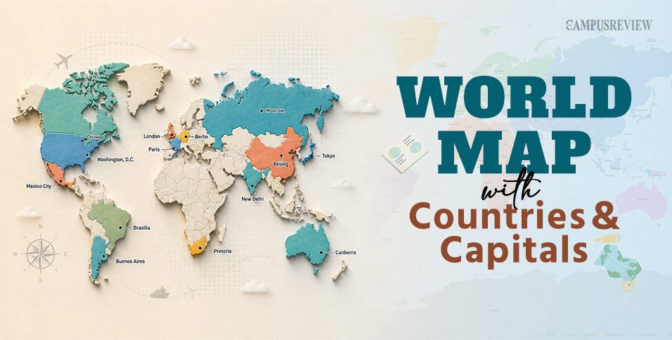
Which country has three capitals? Which capital just changed in 2026? A world map with countries and capitals answers these questions at a glance. It shows every nation, its border, and its seat of government on a single page.
This guide gives you the same picture in text form. You get a continent-wise list of all 195 countries and their capitals, plus the facts students ask about most: how many countries exist, which nations have more than one capital, and which capital city changed just this year. Keep this page open next to the downloadable map PDF below and use both together while you study.
What Is a World Map with Countries and Capitals?
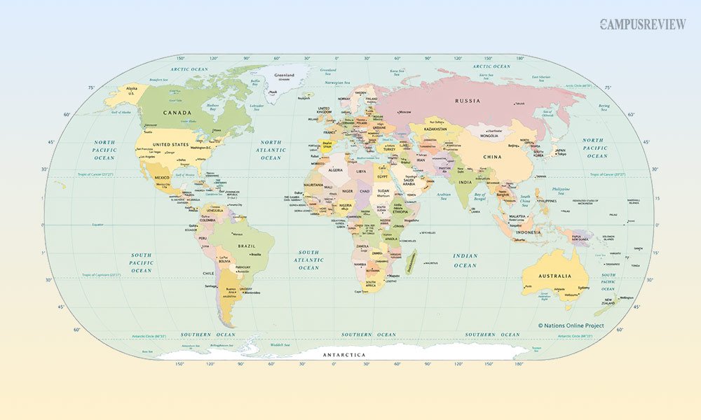
A world map with countries and capitals is a political world map. It shows country borders, not physical features like rivers or mountains. Each country is marked with its name, and its capital city gets a special symbol, usually a star or a dot.
Students use this type of labeled world map for three main reasons:
- To locate a country and its capital quickly during exam prep.
- To understand which countries share a region or continent.
- To connect current affairs news, like a capital city change, to a place on the map.
Download the World Map with Countries and Capitals
Use the downloadable world map with countries and capitals PDF alongside this guide. Print it out or save it on your phone. Every country name and capital city listed below appears on that map, so you can trace each region as you read.
How Many Countries Are There in the World?
The world has 195 countries. This count comes from the United Nations. It includes 193 UN member states and 2 permanent observer states, the Holy See (Vatican City) and the State of Palestine.
Some lists show a different number. That happens when a source counts territories, dependencies, or partially recognised regions. For a standard classroom answer, 195 is the number to use.
How to Read a Political World Map
A political world map follows a few simple rules. Once you know them, any map becomes easy to read:
● Solid lines mark accepted international borders.
● Dashed or dotted lines mark disputed borders or ceasefire lines.
● A star or bold dot marks the capital city, not just any big city.
● A scale bar at the bottom tells you the real distance between two points.
Every flat map also uses a projection. A projection is just the method used to turn the round Earth into a flat image. The Winkel Tripel projection is the most common one today. The National Geographic Society adopted it in 1998 because it keeps size and shape close to accurate across the whole map.
Countries and Capitals of the World by Continent
Here is the full list of countries and capitals, grouped continent by continent. This is the same structure used on the map, so you can match each row to its region.
Africa (54 countries)
Africa has 54 countries, more than any other continent. Its capitals range from coastal cities like Accra and Dakar to inland capitals like Abuja and Nairobi.
| Country | Capital City | Region |
| Algeria | Algiers | Northern Africa |
| Angola | Luanda | Middle Africa |
| Benin | Porto-Novo | Western Africa |
| Botswana | Gaborone | Southern Africa |
| Burkina Faso | Ouagadougou | Western Africa |
| Burundi | Gitega | Eastern Africa |
| Cameroon | Yaoundé | Middle Africa |
| Cape Verde | Praia | Western Africa |
| Central African Republic | Bangui | Middle Africa |
| Chad | N’Djamena | Middle Africa |
| Comoros | Moroni | Eastern Africa |
| Democratic Republic of the Congo | Kinshasa | Middle Africa |
| Republic of the Congo | Brazzaville | Middle Africa |
| Djibouti | Djibouti | Eastern Africa |
| Egypt | Cairo | Northern Africa |
| Equatorial Guinea | Ciudad de la Paz | Middle Africa |
| Eritrea | Asmara | Eastern Africa |
| Eswatini | Mbabane | Southern Africa |
| Ethiopia | Addis Ababa | Eastern Africa |
| Gabon | Libreville | Middle Africa |
| Gambia | Banjul | Western Africa |
| Ghana | Accra | Western Africa |
| Guinea | Conakry | Western Africa |
| Guinea-Bissau | Bissau | Western Africa |
| Ivory Coast (Côte d’Ivoire) | Yamoussoukro | Western Africa |
| Kenya | Nairobi | Eastern Africa |
| Lesotho | Maseru | Southern Africa |
| Liberia | Monrovia | Western Africa |
| Libya | Tripoli | Northern Africa |
| Madagascar | Antananarivo | Eastern Africa |
| Malawi | Lilongwe | Eastern Africa |
| Mali | Bamako | Western Africa |
| Mauritania | Nouakchott | Western Africa |
| Mauritius | Port Louis | Eastern Africa |
| Morocco | Rabat | Northern Africa |
| Mozambique | Maputo | Eastern Africa |
| Namibia | Windhoek | Southern Africa |
| Niger | Niamey | Western Africa |
| Nigeria | Abuja | Western Africa |
| Rwanda | Kigali | Eastern Africa |
| São Tomé and Príncipe | São Tomé | Middle Africa |
| Senegal | Dakar | Western Africa |
| Seychelles | Victoria | Eastern Africa |
| Sierra Leone | Freetown | Western Africa |
| Somalia | Mogadishu | Eastern Africa |
| South Africa | Pretoria | Southern Africa |
| South Sudan | Juba | Eastern Africa |
| Sudan | Khartoum | Northern Africa |
| Tanzania | Dodoma | Eastern Africa |
| Togo | Lomé | Western Africa |
| Tunisia | Tunis | Northern Africa |
| Uganda | Kampala | Eastern Africa |
| Zambia | Lusaka | Eastern Africa |
| Zimbabwe | Harare | Eastern Africa |
Asia (48 countries)
Asia is the largest continent, home to 48 countries and nearly half the world’s population. Its capitals include ancient cities like Beijing and modern planned capitals like Nusantara.
| Country | Capital City | Region |
| Afghanistan | Kabul | Southern Asia |
| Armenia | Yerevan | Western Asia |
| Azerbaijan | Baku | Western Asia |
| Bahrain | Manama | Western Asia |
| Bangladesh | Dhaka | Southern Asia |
| Bhutan | Thimphu | Southern Asia |
| Brunei | Bandar Seri Begawan | South-eastern Asia |
| Cambodia | Phnom Penh | South-eastern Asia |
| China | Beijing | Eastern Asia |
| Cyprus | Nicosia | Western Asia |
| Georgia | Tbilisi | Western Asia |
| India | New Delhi | Southern Asia |
| Indonesia | Nusantara | South-eastern Asia |
| Iran | Tehran | Southern Asia |
| Iraq | Baghdad | Western Asia |
| Israel | Jerusalem | Western Asia |
| Japan | Tokyo | Eastern Asia |
| Jordan | Amman | Western Asia |
| Kazakhstan | Astana | Central Asia |
| Kuwait | Kuwait City | Western Asia |
| Kyrgyzstan | Bishkek | Central Asia |
| Laos | Vientiane | South-eastern Asia |
| Lebanon | Beirut | Western Asia |
| Malaysia | Kuala Lumpur | South-eastern Asia |
| Maldives | Malé | Southern Asia |
| Mongolia | Ulaanbaatar | Eastern Asia |
| Myanmar | Naypyidaw | South-eastern Asia |
| Nepal | Kathmandu | Southern Asia |
| North Korea | Pyongyang | Eastern Asia |
| Oman | Muscat | Western Asia |
| Pakistan | Islamabad | Southern Asia |
| Palestine | Jerusalem | Western Asia |
| Philippines | Manila | South-eastern Asia |
| Qatar | Doha | Western Asia |
| Saudi Arabia | Riyadh | Western Asia |
| Singapore | Singapore | South-eastern Asia |
| South Korea | Seoul | Eastern Asia |
| Sri Lanka | Sri Jayawardenepura Kotte | Southern Asia |
| Syria | Damascus | Western Asia |
| Tajikistan | Dushanbe | Central Asia |
| Thailand | Bangkok | South-eastern Asia |
| Timor-Leste | Dili | South-eastern Asia |
| Turkey | Ankara | Western Asia |
| Turkmenistan | Ashgabat | Central Asia |
| United Arab Emirates | Abu Dhabi | Western Asia |
| Uzbekistan | Tashkent | Central Asia |
| Vietnam | Hanoi | South-eastern Asia |
| Yemen | Sana’a | Western Asia |
Europe (44 countries)
Europe has 44 countries packed into a relatively small area. Many of its capitals, like Paris and Rome, have served as centres of power for centuries.
| Country | Capital City | Region |
| Albania | Tirana | Southern Europe |
| Andorra | Andorra la Vella | Southern Europe |
| Austria | Vienna | Western Europe |
| Belarus | Minsk | Eastern Europe |
| Belgium | Brussels | Western Europe |
| Bosnia and Herzegovina | Sarajevo | Southern Europe |
| Bulgaria | Sofia | Eastern Europe |
| Croatia | Zagreb | Southern Europe |
| Czechia | Prague | Eastern Europe |
| Denmark | Copenhagen | Northern Europe |
| Estonia | Tallinn | Northern Europe |
| Finland | Helsinki | Northern Europe |
| France | Paris | Western Europe |
| Germany | Berlin | Western Europe |
| Greece | Athens | Southern Europe |
| Hungary | Budapest | Eastern Europe |
| Iceland | Reykjavík | Northern Europe |
| Ireland | Dublin | Northern Europe |
| Italy | Rome | Southern Europe |
| Latvia | Riga | Northern Europe |
| Liechtenstein | Vaduz | Western Europe |
| Lithuania | Vilnius | Northern Europe |
| Luxembourg | Luxembourg | Western Europe |
| Malta | Valletta | Southern Europe |
| Moldova | Chișinău | Eastern Europe |
| Monaco | Monaco | Western Europe |
| Montenegro | Podgorica | Southern Europe |
| Netherlands | Amsterdam | Western Europe |
| North Macedonia | Skopje | Southern Europe |
| Norway | Oslo | Northern Europe |
| Poland | Warsaw | Eastern Europe |
| Portugal | Lisbon | Southern Europe |
| Romania | Bucharest | Eastern Europe |
| Russia | Moscow | Eastern Europe |
| San Marino | San Marino | Southern Europe |
| Serbia | Belgrade | Southern Europe |
| Slovakia | Bratislava | Eastern Europe |
| Slovenia | Ljubljana | Southern Europe |
| Spain | Madrid | Southern Europe |
| Sweden | Stockholm | Northern Europe |
| Switzerland | Bern | Western Europe |
| Ukraine | Kyiv | Eastern Europe |
| United Kingdom | London | Northern Europe |
| Vatican City | Vatican City | Southern Europe |
North America (23 countries)
North America covers 23 countries, most of them island nations in the Caribbean. Capitals here range from major global cities like Washington, D.C. to small island towns.
| Country | Capital City | Region |
| Antigua and Barbuda | Saint John’s | Caribbean |
| Bahamas | Nassau | Caribbean |
| Barbados | Bridgetown | Caribbean |
| Belize | Belmopan | Central America |
| Canada | Ottawa | Northern America |
| Costa Rica | San José | Central America |
| Cuba | Havana | Caribbean |
| Dominica | Roseau | Caribbean |
| Dominican Republic | Santo Domingo | Caribbean |
| El Salvador | San Salvador | Central America |
| Grenada | St. George’s | Caribbean |
| Guatemala | Guatemala City | Central America |
| Haiti | Port-au-Prince | Caribbean |
| Honduras | Tegucigalpa | Central America |
| Jamaica | Kingston | Caribbean |
| Mexico | Mexico City | Central America |
| Nicaragua | Managua | Central America |
| Panama | Panama City | Central America |
| Saint Kitts and Nevis | Basseterre | Caribbean |
| Saint Lucia | Castries | Caribbean |
| Saint Vincent and the Grenadines | Kingstown | Caribbean |
| Trinidad and Tobago | Port of Spain | Caribbean |
| United States | Washington, D.C. | Northern America |
South America (12 countries)
South America has 12 countries, and most capitals sit either on the coast or high in the Andes. Brasília and La Paz stand out as planned or high-altitude capitals.
| Country | Capital City | Region |
| Argentina | Buenos Aires | South America |
| Bolivia | Sucre | South America |
| Brazil | Brasília | South America |
| Chile | Santiago | South America |
| Colombia | Bogotá | South America |
| Ecuador | Quito | South America |
| Guyana | Georgetown | South America |
| Paraguay | Asunción | South America |
| Peru | Lima | South America |
| Suriname | Paramaribo | South America |
| Uruguay | Montevideo | South America |
| Venezuela | Caracas | South America |
Oceania (14 countries)
Oceania spans 14 countries scattered across the Pacific. Many capitals here are small island towns, a contrast to the sprawling capitals of larger continents.
| Country | Capital City | Region |
| Australia | Canberra | Australia and New Zealand |
| Fiji | Suva | Melanesia |
| Kiribati | Tarawa | Micronesia |
| Marshall Islands | Majuro | Micronesia |
| Micronesia | Palikir | Micronesia |
| Nauru | Yaren (de facto) | Micronesia |
| New Zealand | Wellington | Australia and New Zealand |
| Palau | Ngerulmud | Micronesia |
| Papua New Guinea | Port Moresby | Melanesia |
| Samoa | Apia | Polynesia |
| Solomon Islands | Honiara | Melanesia |
| Tonga | Nukuʻalofa | Polynesia |
| Tuvalu | Funafuti | Polynesia |
| Vanuatu | Port Vila | Melanesia |
Countries With More Than One Capital
Most countries have one capital. A small number split government functions across two or three cities. This usually happens for historical or political reasons, not because the country lacks a clear centre.
| Country | Capitals | Why It Has More Than One |
| South Africa | Pretoria (executive), Cape Town (legislative), Bloemfontein (judicial) | Agreed at the 1910 Union of South Africa to balance regional interests |
| Bolivia | Sucre (constitutional, judicial), La Paz (executive, legislative) | Compromise after the 1899 civil conflict |
| Netherlands | Amsterdam (constitutional capital), The Hague (seat of government) | Amsterdam holds the title; The Hague holds parliament and the courts |
| Malaysia | Kuala Lumpur (official), Putrajaya (administrative) | Putrajaya was built to ease congestion in Kuala Lumpur |
| Sri Lanka | Sri Jayawardenepura Kotte (legislative), Colombo (executive, commercial) | Government functions moved out of the crowded commercial capital |
| Eswatini | Mbabane (administrative), Lobamba (royal, legislative) | Traditional royal seat kept separate from the administrative seat |
Around 15 countries follow this split-capital model in some form. If you remember these six, you can answer most exam questions on this topic.
Equatorial Guinea’s New Capital: A 2026 Update
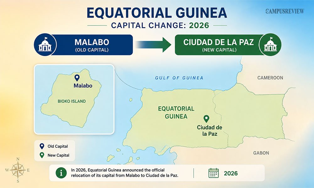
This is the most current change on the world map. On January 2, 2026, Equatorial Guinea officially moved its capital from Malabo to Ciudad de la Paz. Law No. 4/2026 confirmed the move that April.
Malabo sits on Bioko Island, cut off from most of the country’s population on the mainland. Ciudad de la Paz sits inland in Djibloho Province, close to the border with Gabon. The government built the new city to fix that disconnect and to ease crowding in Malabo. The move is happening in phases, and Malabo still works as the country’s main port and commercial hub.
Update this fact whenever you check a world map dated before 2026. It will still show Malabo as the capital.
World’s Biggest and Smallest Capital Cities
Tokyo, Japan: The Greater Tokyo Area holds around 37 to 41 million people. It is the largest capital region on Earth.
Delhi (NCT), India: The National Capital Region holds close to 37 million people, the second largest capital region in the world.
Vatican City: This is the smallest sovereign state in the world, at just 0.49 square kilometres, and it sits inside Rome.
Fun Facts to Remember
- Russia is home to some of the world’s largest forests, including vast stretches of the Siberian taiga.
- Nepal has the only non-rectangular national flag in the world. Its shape comes from two stacked triangular pennants.
- New Delhi became India’s capital in 1911, replacing Kolkata, and was formally inaugurated in 1931.
- Indonesia is shifting its capital from Jakarta to the new planned city of Nusantara.
- Brasília, Brazil’s capital, was built from scratch and opened in 1960 as a planned city.
End Note
A world map with countries and capitals is one of the most useful tools you can keep on hand as a student. It ties together geography, current affairs, and general knowledge in one visual.
Use the continent-wise tables here for quick revision, keep the downloadable map PDF for visual reference, and check back on updates like the Equatorial Guinea capital change so your knowledge stays current.
Frequently Asked Questions
1. What is the capital of India?
New Delhi is the capital of India. It has held that title since 1911, when the British moved the capital there from Kolkata.
2. Which country has the largest capital city?
Tokyo, the capital of Japan, has the largest capital city by population. Its metro area holds close to 40 million people.
3. What is the smallest country in the world?
Vatican City is the smallest country in the world by both land area and population. It sits inside Rome, Italy.
4. What is the difference between a country and a capital?
A country is an independent nation with its own government and borders. A capital is the specific city inside that country where the national government sits.