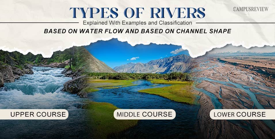
Rivers fall into two main groups. One group is based on water flow, like perennial and ephemeral rivers. The other is based on channel shape, like meandering and braided rivers.
Not every river behaves the same way. Some rivers flow all year without stopping. Others disappear for months, then rush back to life after a single storm. A few even cross entire deserts without drying up. This difference comes down to three things: how much water a river gets, the shape of its channel, and where it sits on the map.
This guide breaks down every major type of river in simple terms, with real examples like the Amazon, the Nile, and the Brahmaputra. You will learn why some rivers run straight, why others loop for kilometers, and why a river can change completely from one season to the next.
What Are the Different Types of Rivers?
Rivers fall into two broad groups. One group is based on water flow. The other is based on channel shape. Here is the quick answer:
| Classification | River Types |
| By water flow | Perennial, Intermittent, Ephemeral, Exotic |
| By channel shape | Straight, Meandering, Braided |
Now let’s look at each type in detail.
Types of Rivers Based on Water Flow
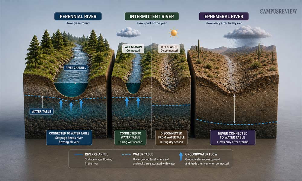
Water flow tells you how often a river actually flows. This depends on rainfall, groundwater, and the water table below the surface. The water table is the underground level where soil and rock stay fully soaked with water. When a river channel dips below this level, the river keeps flowing even in dry weather. When it does not, the river depends on rain instead.
Perennial Rivers
A perennial river flows every single day of the year. This happens because the riverbed sits below the water table. Groundwater keeps seeping upward into the channel, so the river never runs out of water, even during weeks without rain. In colder or mountainous regions, melting snow and glacier water add even more flow during the warmer months.
Because a perennial river never dries up, it can support permanent fish populations, year-round farming nearby, and stable plant life along its banks.
Examples of Perennial Rivers:
- The Amazon River in South America carries more water than any other river on Earth and never stops flowing.
- The Mississippi River in the United States also flows throughout the year, supported by groundwater and steady tributary inflow.
Intermittent Rivers
An intermittent river, sometimes called a periodic river, only flows for part of the year. Its channel touches the water table for just a few months at a time. When the rainy season arrives, the water table rises high enough to reach the riverbed, and the channel fills up.
Once the dry season begins, the water table sinks back down, the channel loses contact with it, and the river dries out or shrinks to a few stagnant pools.
This pattern is common in places with a clear wet season and dry season.
Examples of Intermittent Rivers
- Monsoon regions in South Asia: Some rivers flow during the monsoon season and shrink or dry during the dry season.
- Mediterranean climates in southern Europe: Seasonal rainfall can cause rivers to flow during wetter months and decline during dry periods.
Ephemeral Rivers
An ephemeral river stays dry for almost the entire year. It only carries water for a few hours or days after a heavy storm. Unlike perennial and intermittent rivers, an ephemeral riverbed never touches the water table. It remains permanently above the water table in dry ground.
When a storm hits, rain falls faster than the dry soil can absorb it. The extra water runs off the surrounding land and rushes into the channel, causing a brief flash flood. Within hours, the water either drains away or sinks into the dry ground, and the channel returns to looking like an empty ditch.
Examples of Ephemeral Rivers
Ephemeral river channels are common in desert and other very dry regions.
- Wadis: The term commonly used for these dry or temporary river channels in the Middle East and North Africa.
- Arroyos: A term used for similar channels in the southwestern United States.
These channels may remain completely dry for long periods and carry water only after intense rainfall.
Exotic Rivers
An exotic river is a river that begins in a humid or high-rainfall region and then flows through an arid or desert region. Most of its water comes from the wetter area where the river originates rather than from rainfall along its dry downstream course. Because of this, an exotic river can continue flowing through landscapes that receive very little rainfall.
This makes exotic rivers different from rivers that depend mainly on local rainfall. As an exotic river enters a dry region, evaporation and water loss can reduce its flow. It may also receive few or no significant tributaries because the surrounding landscape is too dry to support them
Examples of Exotic Rivers
- Nile River: The Nile begins near the rainy highlands of East Africa and Ethiopia. It then crosses the Sahara Desert, one of the driest places on Earth, The river survives this desert crossing only because it built up such a large volume of water earlier in its journey. Without that head start, it would run dry long before reaching the Mediterranean Sea.
- Colorado River: The Colorado River begins in the wetter Rocky Mountains and then flows through the arid desert basins of the American Southwest.
The Nile River is a classic example of an exotic river because it carries water from a wet region through an extremely dry environment.
Perennial vs Intermittent vs Ephemeral Rivers
Use this table to compare the three water-flow types at a glance.
| Feature | Perennial | Intermittent | Ephemeral |
| Flow | Year-round | Seasonal | After heavy rain |
| Main water source | Groundwater, snowmelt | Rainfall and groundwater | Storm rainfall |
| Dry periods | Rare | Common | Most of the year |
| Typical setting | Wet or well-watered areas | Seasonal climates | Arid regions |
Types of Rivers Based on Channel Shape
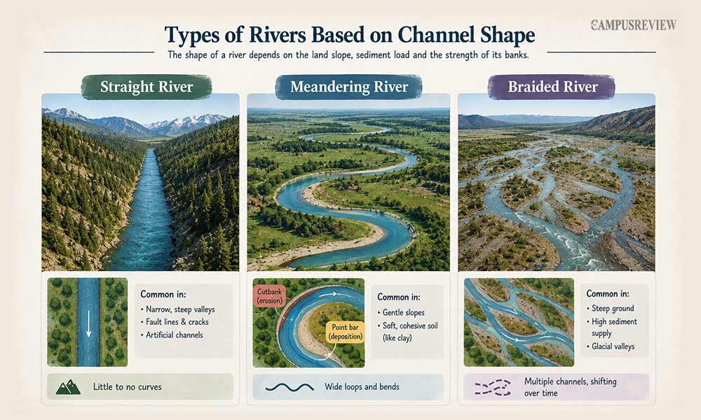
Channel shape tells you how a river looks from above, whether it runs in a straight line, curves in loops, or splits into many threads. This channel shape depends on three things: how steep the land is, how much sediment the river carries, and how strong its banks are against erosion.
Straight Rivers
A straight river follows a fairly direct path with very little curving. True straight channels are rare in nature because flowing water naturally begins to develop curves. Even a small bend in the land or a softer section of the riverbank can push the current sideways and start a curve that grows over time.
Straight channels are more likely to remain where something physically prevents the river from bending. This can include narrow, steep valleys cut into hard rock or cracks and fault lines in the ground that keep the river in a fixed path.
Examples and Settings of Straight Rivers
Straight river channels can occur in:
- Narrow, steep valleys: Hard rock can restrict the river to a relatively direct path.
- Fault lines and geological cracks: These features can guide the river along a fixed route.
- Artificial channels: Engineers may create straight channels for flood control or water management.
Straight river stretches are therefore more common where geological features or human engineering restrict the natural movement of the channel.
Meandering Rivers
A meandering river winds across flat land in a series of sweeping loops and bends. This shape forms where the slope is gentle, and the riverbanks are made of soft, cohesive soil like clay, which holds its shape but still erodes slowly over time.
As water rounds a bend, it moves faster along the outer edge of the curve and slower along the inner edge. The faster water wears away the outer bank, a spot geographers call the cutbank, while the slower water on the inner bank drops the sand and silt it was carrying, building up a point bar.
Year after year, this steady erosion on one side and deposition on the other pushes the loop further outward. During a major flood, the river can cut straight across the narrow neck of an old loop, abandoning it. The cut-off loop then fills with still water and becomes a curved oxbow lake.
Example of a Meandering River
Mississippi River: The Mississippi River shows this pattern clearly, with wide meanders and old oxbow lakes lining its lower stretches.
Braided Rivers
A braided river splits into several smaller channels that constantly divide, rejoin, and shift position, similar to strands of braided hair. This shape develops when a river carries far more sand and gravel than it can move through a single channel.
How Do Braided Rivers Form?
The extra sediment settles in the middle of the flow and builds up into small islands called bars. Water gets pushed around these bars into separate side channels.
Because the banks here are loose sand and gravel rather than solid clay, they crumble easily. As a result, the channels keep shifting and rearranging after every flood.
Braided rivers usually form on steep ground with a heavy sediment supply, such as valleys fed by melting glaciers.
Example of a Braided River
Brahmaputra River: The Brahmaputra River, flowing through India and Bangladesh, is the largest braided river on Earth. It carries enormous volumes of sediment down from the Himalayas.
Straight vs Meandering vs Braided Rivers
Here is a simple side-by-side comparison of the three channel shapes.
| Feature | Straight | Meandering | Braided |
| Channel | Single, direct | Curved | Multiple, connected |
| Shape | Straight line | Loops and bends | Interweaving channels |
| Common setting | Steep, narrow valleys | Flat plains | Sediment-rich, wide valleys |
How Rivers Change From Source to Mouth
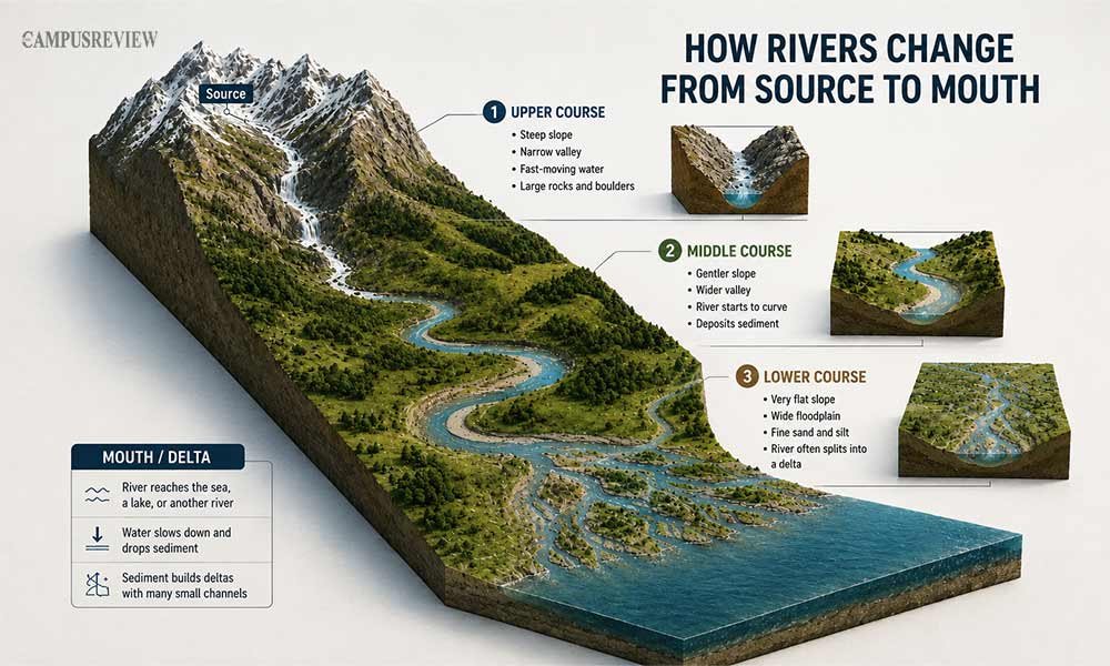
Every river changes shape and speed as it travels from its source to its mouth. This journey has three main stages.
| Stage | What Happens |
| Upper course (near the source) | Steep slope, narrow valley, fast-moving water, large rocks and boulders |
| Middle course | Gentler slope, wider valley, the river starts to curve and deposit sediment |
| Lower course (near the mouth) | Very flat slope, wide floodplain, fine sand and silt, the river often splits into a delta |
At the river mouth, the river reaches the sea, a lake, or another river. Here, the water slows down and drops the sediment it has carried the whole way. These river routes can span several regions and countries, as shown on a world map.
This can build a delta, where the river splits into many small channels before reaching open water.
Famous Examples of Different River Types
Real rivers help make these categories easier to picture.
| River Type | Example | Where It Is |
| Perennial | Amazon River | South America |
| Exotic | Nile River | Northeastern Africa |
| Meandering | Mississippi River | United States |
| Braided | Brahmaputra River | India and Bangladesh |
Importance of Rivers
Here are the main reasons rivers are essential to people, ecosystems, and economies.
1. Rivers Provide Freshwater
Rivers are an important source of freshwater for people around the world. They hold under 1% of the planet’s surface freshwater, according to the U.S. Geological Survey, yet billions of people rely on rivers for drinking water every day. Rivers also help recharge groundwater, which supplies wells located far from riverbanks.
2. Water and Fertile Soil for Agriculture
Agriculture depends heavily on rivers. When rivers flood their banks, they spread a fresh
layer of nutrient-rich silt across nearby farmland. This naturally renews soil nutrients. Ancient civilizations, such as ancient Egypt along the Nile, built farms near riverbanks and benefited from this fertile soil for thousands of years.
3. Habitats for Plants and Animals
Rivers support entire ecosystems. Fish, birds, and countless plant species depend on rivers for water, food, and habitat. Riverbanks also provide important environments for many species. When a river disappears, the interconnected web of life that depends on it can also collapse.
4. Support Trade and Transportation
Rivers have played an important role in human trade and transportation. Navigable rivers, such as the Mississippi and Rhine, connect inland cities with wider global trade routes. This makes it easier and cheaper to transport goods between different regions.
5. Production of Hydroelectric Power
Fast-flowing sections of rivers can generate hydroelectric power. Hydroelectric facilities use the movement of flowing water to produce electricity, which can supply nearby regions.
6. Development of Cities and Civilizations
Rivers have played a major role in the development of human civilization. Many major cities grew beside rivers because they offered several advantages at once, including reliable drinking water, fertile farmland, and access to trade routes.
Final Thoughts
Rivers are never one-size-fits-all. Understanding the types of rivers means looking at how water flows and how the channel is shaped. Once you know these patterns, you can identify almost any river in the world just by looking at it.
Next time you study a river on a map, ask two questions. Does it flow all year? Does it run straight, curve, or split into many channels? Those two answers can tell you a lot about how that river behaves.
Frequently Asked Questions About River Types
1. What are the three types of river channels?
The three channel shapes are straight, meandering, and braided. Straight channels run in a fairly direct line. Meandering channels curve and loop. Braided channels split into many shifting threads.
2. What is the difference between a meandering and braided river?
A meandering river has one curving channel. A braided river has several channels that split, weave, and rejoin around sand or gravel bars.
3. Why do rivers have different channel shapes?
Channel shape depends on the slope of the land, the type of sediment the river carries, and how strong the riverbanks are. Steep slopes and loose sediment tend to create braided channels. Flat land and cohesive banks tend to create meandering channels.
5. What are the three stages of a river?
A river generally has an upper course, middle course, and lower course. Its slope, channel width, flow, and sediment load change as it moves from its source toward its mouth.