World Geography helps us understand Earth, its physical features, and the people who live across its diverse regions. It covers continents, oceans, mountains, rivers, deserts, climate zones, countries, cities, cultures, and populations.
Geography also explains how people interact with their environment and how natural processes shape the planet. From the world’s largest continent to its deepest ocean and highest mountains, Earth has remarkable geographical diversity. This guide explores the major topics and important facts about geography around the world.
What Is World Geography?
World geography is the study of Earth’s land, water, climate, and people. It has two main branches.
Physical geography of Earth focuses on the natural features and processes that shape our planet. It covers mountains, plains, plateaus, valleys, rivers, lakes, glaciers, oceans, and other land and water features. It also examines weather, climate zones, atmospheric circulation, earthquakes, volcanoes, and plate tectonics.
Together, these elements help us understand how Earth’s physical environment forms, changes, and interacts.
Human geography of the world studies how people live, move, and interact with places and environments. It covers population and settlement patterns, cities, languages, cultures, migration, trade, and the relationship between people and their surroundings.
A river shows this link well. The river itself is a physical feature. But the farms, dams, and cities built along it belong to human geography. Both branches work together. That is why geography connects science with everyday life.
Modern geographers also lean on tools like satellite imagery and GIS, short for Geographic Information Systems. These tools track floods, forest loss, and city growth in near real time. They turn old-style mapmaking into a data-driven field.
Continents of the World
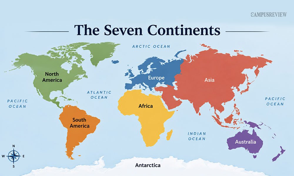
Most schools teach seven continents. Geographers rank them by land area, largest to smallest.
| Continent | Area (approx.) | Key facts |
|---|---|---|
| Asia | 44.6 million km² | Largest continent. Home to Mount Everest and over 4.7 billion people. |
| Africa | 30.4 million km² | Second largest. Contains 54 countries and the Sahara Desert. |
| North America | 24.7 million km² | Stretches from the Arctic to Panama. Includes the Rocky Mountains. |
| South America | 17.8 million km² | Home to the Amazon Basin and the Andes, the longest mountain range on land. |
| Antarctica | 14.2 million km² | Coldest, driest, and windiest continent. No permanent population. |
| Europe | 10.2 million km² | Small in size but dense in countries and history. |
| Australia/Oceania | 8.5 million km² | Smallest continent. Known for its dry interior and unique wildlife. |
Europe and Asia form one connected landmass. Geographers often call it Eurasia. However, they usually treat Europe and Asia as separate continents because of historical and cultural differences.
Continents also help us understand global patterns. Their location affects climate, trade, transport, population, and settlement.
Countries and Capitals of the World
The world has 195 countries today. This count includes 193 UN member states plus two observer states, the Holy See and Palestine.
A capital is usually the main political centre of a country. It is not always the country’s largest city.
| Country | Capital | Bigger, non-capital city |
|---|---|---|
| Australia | Canberra | Sydney |
| Brazil | Brasília | São Paulo |
| Nigeria | Abuja | Lagos |
| Türkiye | Ankara | Istanbul |
| South Africa | Pretoria, Cape Town, Bloemfontein | Johannesburg |
South Africa runs three capitals at once. Pretoria handles the executive branch. Cape Town holds the parliament. Bloemfontein hosts the courts. This kind of detail makes countries and capitals of the world a fun topic to explore beyond rote memorisation.
World Maps and Geographic Regions
Maps help us understand where places are located. But a flat map cannot show a round Earth without some distortion.
Four basic ideas help students read a world map:
- Equator: Divides Earth into the Northern and Southern Hemispheres.
- Prime Meridian: Forms the main reference line for the Eastern and Western Hemispheres.
- Latitude: Measures distance north or south of the Equator.
- Longitude: Measures distance east or west of the Prime Meridian.
The Equator divides Earth into the Northern and Southern Hemispheres. The Prime Meridian is used with the opposite meridian to define the Eastern and Western Hemispheres.
Map projections can also change how countries and continents look. The Mercator projection is useful for navigation, but it can make areas near the poles appear much larger than they really are.
Geographic regions can also follow culture, history, language, or shared physical features. Examples include Southeast Asia, Scandinavia, Sub-Saharan Africa, and the Middle East.
Oceans and Seas
Oceans cover about 71% of Earth’s surface. That single fact explains why water dominates most maps of the world.
| Ocean | Rank by size | Standout fact |
|---|---|---|
| Pacific | Largest | Contains the Mariana Trench, the deepest point on Earth |
| Atlantic | Second largest | Splits the Americas from Europe and Africa |
| Indian | Third largest | Shaped strongly by seasonal monsoons |
| Southern | Fourth largest | Circles Antarctica; officially recognized since 2000 |
| Arctic | Smallest | Mostly covered by sea ice |
Smaller seas sit inside or beside these oceans. The Mediterranean, Caribbean, Red Sea, and South China Sea all fall into this group. Seas and oceans support fishing, shipping, and tourism. They also face real pressure today from warming water, plastic pollution, and rising sea levels.
Major Landforms of the Earth
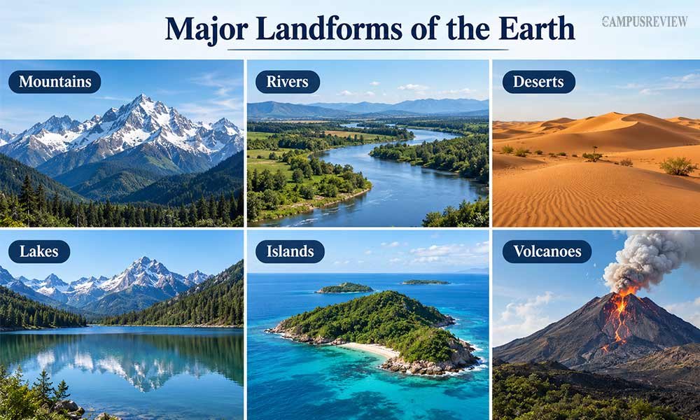
Landforms are important parts of Earth’s physical geography. They influence climate, water, ecosystems, farming, travel, and human settlement.
Mountains
Mountains can affect rainfall, climate, rivers, and settlement. They can also store freshwater as snow and ice.
The Himalayas are a major example. Their formation is linked to the collision of the Indian and Eurasian tectonic plates. The region continues to experience tectonic activity today.
Rivers
Rivers change landscapes through erosion and the movement of sediment. They provide water for people, farming, wildlife, and ecosystems.
Many major cities and early civilisations developed near rivers because rivers provided water and supported agriculture and trade.
Deserts
Deserts receive very little precipitation. They can be hot or cold.
Their dry conditions affect plants, animals, farming, settlement, and access to water. Large deserts also influence regional climate and human activity.
Lakes
Lakes store freshwater and support plants, animals, communities, and agriculture. Large lakes such as Lake Baikal are important examples of Earth’s freshwater systems.
Islands
Islands are surrounded by water and can form important countries, regions, and ecosystems.
Their geographic isolation can also lead to unique plants, animals, cultures, and settlement patterns.
Volcanoes
Volcanoes can create and reshape land. Eruptions can form mountains, islands, and new layers of rock.
Volcanic activity is closely connected with the movement of tectonic plates. USGS research shows that volcanoes are strongly linked to plate boundaries, although some also form away from those boundaries.
World Climate Zones
Climate is not the same as weather. Weather changes day to day. Climate is the average pattern over many years.
| Climate zone | What it feels like |
|---|---|
| Tropical | Warm all year, heavy rain in some seasons |
| Dry | Low rainfall; includes hot and cold deserts |
| Temperate | Clear seasons, moderate rain |
| Continental | Hot summers, cold winters, big swings |
| Polar | Cold all year, little rainfall |
| Highland | Climate shifts fast with elevation |
Latitude decides most of this pattern. Places near the Equator stay warm. Places near the poles stay cold. Ocean currents also matter. The Gulf Stream keeps Western Europe milder than other places at the same latitude.
Climate Change: How It Is Reshaping Earth’s Geography
Climate change refers to long-term changes in Earth’s climate patterns. It is now changing many parts of the planet’s physical and human geography.
NASA reports that Earth’s average surface temperature has risen by about 1°C since the late 19th century. NASA also identifies human activities and rising carbon dioxide levels as major drivers of current warming.
Climate change affects:
- Coastlines: Rising sea levels can increase risks for low-lying coastal areas.
- Glaciers: Warmer temperatures are causing many glaciers to lose ice.
- Rivers: Changes in snow and ice can affect water supplies.
- Agriculture: Changes in rainfall and temperature can affect growing conditions.
- Ecosystems: Plants and animals may shift into new areas as conditions change.
- Oceans: Warmer waters can place additional stress on marine ecosystems.
NASA’s sea-level research also shows that global sea levels have risen as the climate has warmed, with melting land ice and ocean warming contributing to the rise.
Climate change is therefore not only an environmental issue. It is also a geography issue because it changes landscapes, resources, ecosystems, and where people can live.
Human Geography of the World
Human geography studies the relationship between people and places. With more than 8 billion people living on Earth, human activities have a major influence on the planet’s landscapes, resources, and environments.
People build cities, cultivate land, extract resources, create transportation networks, and move between regions. At the same time, geography influences where people settle, how they live, and how communities develop.
Then you can cover 5 key areas:
- Population: Where people live and why certain regions have much higher population densities.
- Cities and settlements: How rivers, coastlines, resources, climate, and transportation influence where cities develop.
- Agriculture and land use: How farming transforms forests, grasslands, and other landscapes to produce food.
- Migration and movement: How people moving between regions changes population patterns and creates new cultural and economic connections.
- Human impact: How urbanisation, industry, mining, deforestation, and resource use transform Earth’s surface and ecosystems.
Settlement patterns rarely happen by accident. Most major cities grew near rivers, coastlines, or fertile plains, because water and flat farmland support large populations.
Trade shaped this pattern further. Ports along the Strait of Malacca or the Suez Canal grew into major cities simply because ships needed to pass through them. Geography and economics often move together, not apart.
How to Study Geography Effectively
Learning geography facts for a test can be useful, but remembering them over time requires regular practice. A good approach is to build a mental map and understand how places and geographic features connect.
1. Start with a blank map. Use an unlabeled world map to mark continents, oceans, countries, and major physical features from memory. Then check your answers. This method helps reinforce what you have learned.
2. Learn by region. Group countries by continent or region, such as Southeast Asia, South America, or Northern Europe. Smaller groups can make locations easier to remember and help you understand connections between nearby countries.
3. Understand the reasons behind geographic features. Instead of only memorising that the Himalayas are high, learn about the tectonic plate movements that formed them. Understanding how and why features develop can make geographic facts easier to remember.
4. Use maps and real-world tools. Practice with interactive map quizzes, explore satellite images, watch geography videos, and follow news from different parts of the world. These resources can help connect geographic information with real places and events.
5. Review topics regularly. Revisit topics after a few days and then again after a few weeks. Regular review can help you retain information and reduce the need for last-minute revision.
6. Ask “why,” not only “where.” Knowing where the Amazon River is located provides basic geographic knowledge. Asking why the river carries large amounts of water can help you understand rainfall, climate, and physical geography.
7. Connect geography with current events. Locate the places mentioned in major news stories on a map. This can show how geography relates to areas such as climate, migration, trade, politics, and daily life.
Final Thoughts
World geography covers much more than capitals and maps. It helps explain where people live, how natural features form, and how physical changes on Earth can affect communities and regions.
Start by learning the physical geography of Earth. Then build on that knowledge with human geography. This approach can make it easier to understand how natural features and human activities are connected.
FAQs
1. What are the 4 types of geography?
The four types are physical, human, cultural, and economic geography. They examine Earth’s natural features, people and places, culture, and economic activities.
2. What’s the difference between physical and human geography?
Physical geography studies natural features and processes such as mountains, rivers, oceans, and climate. Human geography studies people, settlements, migration, culture, and their relationship with places.
3. What are the five themes of geography?
The five themes are location, place, human-environment interaction, movement, and region. They help explain where places are, what makes them different, and how people and places are connected.
4. How do mountains affect the climate of nearby areas?
Mountains can influence temperature, rainfall, and wind patterns. They can force moist air to rise, which can produce more rainfall on one side of a mountain range and create drier conditions on the other side.